Save this image free of charge
in 800 pixels for layout use
(right click, Save as...)
|
|
Ref : T01321
Theme :
Looking at Earth - Sea - Coast - Capes - Peninsula (601 images)
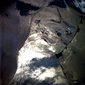
Title : Gulf Stream Near Cape Hatteras, North Carolina May 1991
Caption :
The western boundary (left on image) of the north flowing Gulf Stream is visible in this image. North is visible towards the bottom. The bright white area seen in the image is the reflection of the sun off the water or sunglint. The waters of Pamlico Sound are visible along the right side of the image. Cape Hatteras and the accompanying Barrier Sand Islands can be seen to the east of the waters of Pamilco Sound. The Gulf Stream Ocean current flows north in the western Atlantic Ocean 10 to 500 miles (16 to 800 km) east of the coast of the United States. The Gulf Stream is not a “river of hot water”, but is instead a narrow (60 miles—100 km) high velocity flow of water that separates the cold, dense water to the west near the coast of the eastern United States, from the warm waters of Sargasso Sea to the Gulf Stream’s east. The current extends from near the Straits of Florida to an area off of the Grand Banks near 40 degrees north latitude, 50° west longitude. Near Cape Hatteras, the Gulf Stream widens as it begins to flow over the Continental rise. The current also begins to grow deeper reaching down to depths of 13000 to 16000 feet (4000 to 5000 meters). Water temperatures in the Sargasso Sea range from near 68 to 75?F (20 to 24?C). Coastal waters near the eastern United States range from 54 to 68?F (12-24?C). At the Grand Banks, the Gulf Stream turns to the east and becomes the North Atlantic Current.
|
|

